Deep Sea Fish and Sediment Surveys in the Gulf
On Dry land
Posted by K.Bylsma ,C-Image Teacher at Sea for Monday, August 11 0500.
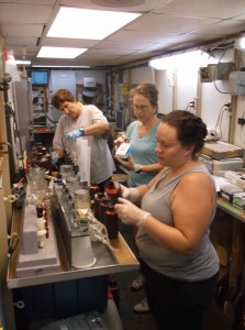
The routine has been WHENEVER you get up, it’s time to work, so here I am. From Bayboro Harbor in St. Petersburg throughout the Gulf at 12 stations; collecting CTD samples 21 different times ;Shipek sampling soils at 10 locations; Bongo nets collecting biomass at 12 locations; and either the SHIPPER 3 or the SHIPPER 4 collecting images at 13 different times ( for often 5 hours at a time), it’s time to analyze the data.
What have we learned?
· ****we each have a role in protecting our environment
· ****all systems have a delicate balance to maintain and are impacted by their surroundings
· *****research requires an enormous amount of time and expertise which invariably leads to more questions than answers
· ****while the Gulf creates Florida’s weather patterns, providing us with innumerable resources, our anthropogenic footprint is already visible. We have to decide how indelible that footprint will be.
*****How will the chemical, biological, geological data guide our decisions? ( I’m certainly hoping that we take the data seriously and make sound decisions based on that data because ….. that’s science !
| Print article | This entry was posted by greely on August 15, 2013 at 10:36 pm, and is filed under Oceanic Updates. Follow any responses to this post through RSS 2.0. You can leave a response or trackback from your own site. |


