Adventures at Sea
Deep Sea Fish and Sediment Surveys in the Gulf
Deep Sea Fish and Sediment Surveys in the Gulf

Feb 8th
Life on board the R/V Weatherbird II got a bit uncomfortable this morning. In many cases, the weather and seas dictate what can be done on a research vessel. There are many pieces of delicate scientific equipment on board that must be secured. Anything that isn’t secured will find its way to somewhere it shouldn’t be and could possibly be broken. Also, when deploying large pieces of equipment such as the multicorer, CTD, or the SIPPER, things can get a bit dicey. The last place you would want to be is between one of these and the ship when the ship is rocking. Not to mention, it is pretty difficult to perform tasks such as filtering, which involves handling small, carbon cleaned filter papers while wearing gloves and only handling them with forceps; not to mention that we are pouring water into it! Today the multicorer was deployed; but, by the time it reached the surface after being bounced around, the core samples were gone! The data being collected from each of these stations is very important in the effort to get a scientific picture of what is occurring in the Gulf of Mexico.

Feb 8th
Thursday, February 7, 2012
Last night, the water filtering went smoothly except for the dreaded “blank” sample. In this sample, instead of using one filter paper, they use two! This increases the resistance in the suction and increases the time it takes to filter 2 liters of seawater exponentially. The reason they do this is to check the second filter to see if anything is making it through the first filter. It is just a way of ensuring that they are not missing anything. After the CTD, bongo net, and multicore, they deployed the “SIPPER”. This is the device, which resembles a sled that they pull behind the boat at various depths while it is linked to a computer, retrieving massive amounts of data on both physical parameters and how much and what kind of plankton are down there without actually having to catch it! The Weatherbird II crept along at a slow pace all night long pulling this device behind it. It wasn’t finished until 5:30 this morning! We just had a breakfast casserole and are waiting to get to the deep, deep, stations.

Feb 8th
High Seas for Thursday
Whew some very high seas for the Weatherbird II today. We had to discontinue operations at our deepest stations and head the vessel through two fronts as we moved towards the shallower water stations in search of less confused sea states. The safety of all aboard is first and foremost and deploying the large, heavy instruments you have seen in these blogs is not safe when seas are beyond 4-6 feet. So, it was a day of preparing the lab stations, replacing some gear, and catching up on sleep before the non-stop sampling begins at 06:00. Enjoy tonight’s photo journal.

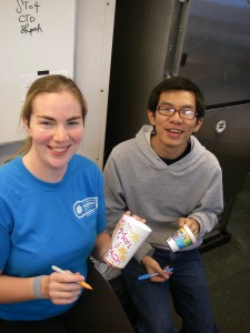
USF Graduate Students, Elizabeth Brown andBo Yang, combining art & science by preparing foam cups for a 1500m plunge

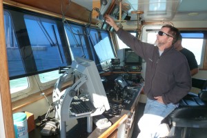
Our Captain, enduring called Boomer.

Feb 8th

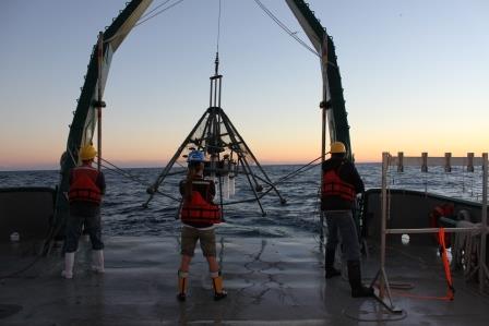
Multicore launch to collect deepsea sediment samples. Scientists Brian Wells, Leslie Wade and Lee Russell
February 6, 2013
After getting a good night’s rest we were greeted by the smell of a hot breakfast of blueberry pancakes, hash browns, sausage, bacon; and of course, fresh fruit. There seems to always be fresh fruit and vegetables at every meal. It wasn’t long after breakfast that we approached the next sampling location.
This location resulted in good core samples. It seemed deep to me being 505 meters down; but it was actually relatively shallow for the Gulf which is over 3000 meters in several locations. One thing that we all know is that the oceans are very cold on the bottom. It was very evident in the tubes as there was condensation on the outside.
Now it’s a waiting game until we get to the next site.
I just received my training on how to do the water filtration for the CHN analysis.
That’s Carbon, Hydrogen, and Nitrogen. The Nisken bottles were brought to the surface and everyone jumped into action; each person taking their water samples for their own individual purposes. My samples were last to be drawn as I waited in the “long lab” with the water filtration system ready to go.
While I was busy filtering, just focusing on my little piece of the puzzle, chief scientist, Leslie and Matt, who is a student from Eckerd College, deployed the bongo net. This is two gigantic plankton nets pulled side by side, and as the name implies, the ring around the front resembles bongos.

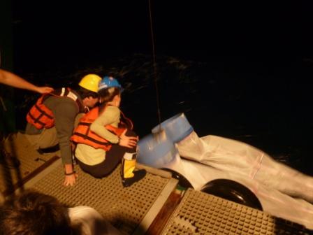
C-IMAGE Chief Scientist, Leslie Wade and Eckerd College student, Matt Russell retrieving the Bongo Nets during nightime sampling of plankton community.
It is 10:30PM now and I am waiting for the second sample series to arrive from this site. Because the water depth was 1200 m we needed to do two casts of the Niskin bottles to collect enough water at each depth. The rosette is set up to hold 12 Niskin bottles.

Feb 7th
The first Sampling Stations
The Weatherbird II reached its first sampling stations west of Tampa Bay. They were relatively shallow water depths where we collected water and sediments for other researchers who requested offshore samples. It also acted as a great training session for me and the other “greenhorns” on the vessel to get a grasp of how to deploy and retrieve the equipment. At these stations we lowered the rosette of Niskin bottles with the CTD and instrument package in a cradle below the bottles. This array of instruments is operated via an electronics cable attached to a computer on the ship that gives the scientists a real time profile of the water column as they slowly lower it down. The water column data profiled conductivity, temperature and depth (CTD), as well as fluorescence of the water.
Ready to deploy Niskin bottles to collect seawater samples at discrete depths. They lower the rosette of bottles to the bottom; and as they hoist it back toward the surface they start activating the sampling bottles. Each Niskin bottle closes and traps water from different depths/layers. When brought to the surface they pull water from each sample for a variety of purposes. Scientists on the ship are set up in the lab and ready to go when these samples arrive at the surface. One of the most tedious processes I observed at these first locations was the filtering of the water for further analysis. On a separate cable they sent down a heavy Shipek sediment sampler. This is what I would call a bottom grab sampler.
Before sending it down they have to cock it in the open position. It is spring loaded with a really heavy spring. When it hits bottom, it fires, like a bear trap, scooping up about a gallon of sediment from the bottom.
This morning, I suppose because these stations were so close to shore, the bottom was still very firm and mostly sandy at the first station, and eventually became silty the further out we went. We also deployed the multi corer and couldn’t get it to go into the firm sand; despite adding more weight. The multi corer is a large, heavy, round apparatus with an array of clear tubes that are also “set” to close when they are embedded into the bottom and pulled up. They look like they pull up approximately 2 feet of the bottom.

Feb 7th
At Sea Journal of Matt MacGregor, February 5, 2013
Morning
Our first day at sea started at the USF’s College of Marine Sciences where we met the R/V Weatherbird II at 7:00 A.M. We had a brief meeting and a survival suit drill. I guess there’s a first time for everything. I can say that I’ve never put on a survival suit before; but, I’m glad to have tried in case the real occasion should arise. It was a beautiful day to go out and I made a point of making any last cell phone calls before exiting Tampa Bay. It’s been many years since I have been in a “cellular dead zone” the size of the Gulf of Mexico! I’m down below right now and can start to feel the difference in the swell. It is time to go on deck so that I can see the land disappear on the horizon.
Lunchtime
Our first lunch on board was a true morale booster, not that morale is bad. I just know that sometimes the quality of the
food on a long journey at sea can be a huge deal when you really need it.

Feb 6th
Meet Matt MacGregor is a marine science teacher at Escambia High School in Pensacola Florida. Matt MacGregor is a lifelong resident of Florida, having grown up on the shores of Perdido Bay, the “Lost Bay” in the panhandle. He gained an appreciation of Florida’s resources while catching blue crabs, mullet, and flounder with his family. He has always maintained a close relationship with the ocean. In fact, he has spent all 41 years of his life living on the water; ten of which were on a sailboat. After completing his education at the University of West Florida and pursuing his interests in sailing, he became a science teacher in Escambia County where he currently teaches Marine Science at Escambia High School. Matt enjoys bringing life to his classroom by including his students in local environmental projects such as Living Shorelines and Oyster Gardening. Matt lives his life through hands-on experiences and now enjoys fostering his two young daughters’ desire to learn about the local estuary by taking them on the boat every opportunity they get. When the opportunity arose to be the C-IMAGE Teacher at Sea Matt quickly jumped on board and is eager to work and share his experiences with his students and others.

Feb 6th
C-IMAGE Outreach & Communication
University of South Florida
In the coming days our team of C-IMAGE scientists from across Florida, led by Leslie Schwierzke-Wade of USF’s College of Marine Science, will be sampling at 13 locations off Florida’s northern Gulf Coast, including many sites we first visited in 2010 following the Deepwater Horizon blowout event. At each of these locations, we will collect seawater at depths ranging from the surface to 2300 meters in search of the ocean grazers at the lower end of the water column food web. These include the ocean’s small but mighty members: the recyclers—microbes, the primary producers—phytoplankton, and the primary consumers—zooplankton, including forams. Join us for daily blog posts highlighting our C-IMAGE science, people and life at sea. You can also follow us on the C-IMAGE Facebook page.
Cruise description: The goal of this cruise is to investigate the impact of the BP oil spill on the northern Gulf of Mexico ecosystem, focusing on the lower end of the water column food web. Researchers from the College of Marine Science/USF and Florida State University will assess the impact of oil on Florida marine ecosystems by comparing non-impacted west Florida shelf and impacted north Florida shelf sites. The expedition will specifically assess benthic, microbial, phytoplankton, and zooplankton communities in relation to oil concentrations. Kendra L. Daly is the C-IMAGE scientist leading research on the abundance and distribution of plankton in the Gulf. Eventually data from this expedition will contribute to an ecosystem model of the Gulf (C-IMAGE scientists, Cameron Ainsworth and Chuanmin Hu).
Geographic Area. The cruise will originate and terminate at USF/CMS in St. Petersburg, FL. We will collect samples along two transect lines. One transect (PCB) extends across the shelf from Panama City and over the DeSoto Canyon. The second transect (DSH) is located to the south of Mobile Bay. There are a total of 13 stations.
This CIMAGE Expedition is funded by a grant from the BP/The Gulf of Mexico Research Initiative. Contract #SA 12-10/GoMRI-007

Nov 16th
Abby Madeiros, Eileen Hayes
Sailing a vessel deploying such technical equipment is a big responsibility, but the crew of the RV Bellows does a fantastic job.
Captain Dave Coy
Dave started out as an office worker in Philadelphia and moved to Florida when his company relocated here. When his company downsized in 2008, he decided to get his captain’s license. He has worked at the Florida Institute of Oceanography for four years on the R/V Weatherbird II and the R/V Bellows. He has served in many capacities, including deck hand, engineer, assistant captain, and captain. He enjoys his job because he loves being out on the water!
Assistant Captain Billy Coker
Billy started working on ships in 2004. He worked several years ferrying materials from Alabama out to the Oil rig platforms. He took the Coast Guard Captains test to allow him to be one of our captains. His duties besides assisting the captain are to help with launching and retrieving equipment. His most exciting trips in the Gulf allowed him to see whales and 20 foot manta rays.
Patrick Foster-marine Cook and Deck Hand
Patrick is a chef extraordinaire in a very small galley. He produces 3 full meals a day and usually a home-made dessert each evening. Meals are at 0700, 1200, and 1800 hours. Patrick also keeps the ship neat and must shop for all the supplies. He says that lunch is the most difficult meal to plan for, so many times it’s soup and sandwiches that people can eat while they work.
David Kennedy-Chief Engineer
David is the one who helps deploy all of the equipment, and he keeps everything running smoothly. He learned to do this job in the Coast Guard, and he was able to travel all around Central America. He likes this job because it allows him to be on the water and fish on the way in.
One of his most memorable research cruises was fishing for sharks using long lines and seeing a 6 gill shark that was 14 feet long and maybe 2000 lbs.

Nov 14th
Eileen Hayes
There have been strange sightings reported on the Bellows! At first we shrugged it off, especially since the scientists have been working round-the-clock on long 12-hour shifts (and often longer!) But as more people have reported catching a glimpse of some gray fur and a green jersey, an investigation was conducted. Now it’s official: we have found a stowaway! His name is Rocky D. Bull, or “Rocky” for short! See if you recognize our little visitor!